| |
Home >
Posets - Maladeta N.P.
|
|
Índice de Rutas
|
|
| |
|
|
| |
|
| |
|

|
The Posets - Maladeta Natural Park was declared park in 1994 to safeguard the geomorphological formations, vegetation and flora. It is part of the Nature Network Aragon and Special Protection Area for Birds and Site of Community Importance under the EU regulations.
Comprises the regions of Sobrarbe, in the municipalities of Gistaín and San Juan de Plan and the region Ribagorza, in the municipalities of Sahún, Benasque and Montanuy.
It occupies a extesion of about 33,400 hectares with a Peripheral Protection Zone of about 5290 hectares.
It houses the largest number of peaks over 3000 m. and contains more than 95 glacial lakes with many waterfalls. Also within its boundaries include three Natural Monuments of the Pyrenean Glaciers: Massif de la Maladeta or Mountains Malditas (cursed), which highlights the Aneto (3404 m), Massif Perdiguero and Massif Posets or Llardana.
From these natural monuments are of great interest its forms of modeling glacier like moraines and mountain lakes, and karst phenomena.
One of the best ways to even observe all summits of the Park from the Aneto to Posets is using the chairlift that leaves the Ampriu, a place that is reached via the road from the town of Cerler.
|
|
|
|
|
|
|
|
| |
| |
|
|
|
|
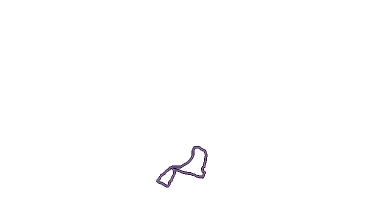
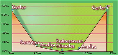
Location |
Cerler. |
| Departure Point |
Cerler |
| Arrival Point |
Cerler |
| Distance |
Cerler 17Km. (Roundtrip). |
| Approximate time |
6h (Roundtrip) |
| Maximum height |
Cerler - 1550 m. |
| Unevenness |
450m. |
Accumulated ascent |
639m. |
| Difficulty |
Low |
| Suitable time |
All year |
| Notes of interest |
Although it is a route that can be done year round, be careful with the snow that may be in the winter time. We must also note that even a fairly level route is long and you must go prepared to walk.
If you like to see old houses and different escutcheon, the villages of Benaque, as well as Cerler and Anciles are ideal, simply stroll through the streets to see wonders.
|
| GPS |
>>Download Track<<
|
|
|
|
| |
|
|
|
|
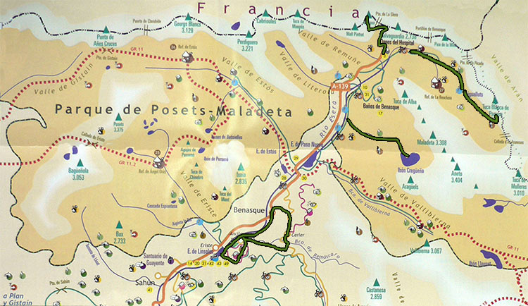
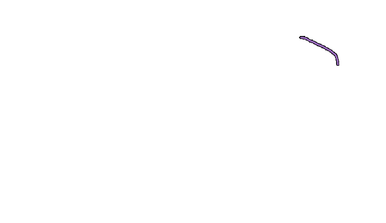
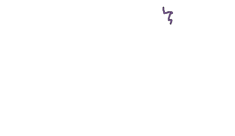
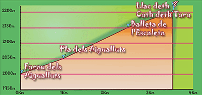
Location |
Plan de l'Hospital. Benasque. |
| Departure Point |
Forau dels Aigualluts |
| Arrival Point |
Forau dels Aigualluts |
| Distance |
3.5Km.(Outward). |
| Approximate time |
2.5h (Outward) |
| Maximum height |
Coth deth Toro - 2240 m. |
| Unevenness |
210 m. |
Accumulated ascent |
270 m. |
| Difficulty |
Low |
| Suitable time |
All year. In winter its needed to wear snowshoes because it is snowy. |
| Notes of interest |
This route continues from Plan dels Aigualluts Route .
Its worth doing it to see the huge lake Llac Coth deth Toro right on the frontier with Vall d'Aran .
|
| GPS |
>>Download Track<<
|
|
|
|
| |
|
|
|
|
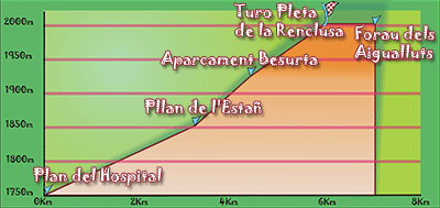
Location |
Plan de l'Hospital. Benasque. |
| Departure Point |
Plan de l'Hospital |
| Arrival Point |
Forau dels Aigualluts |
| Distance |
7Km. (Outward). |
| Approximate time |
2h (Outward) |
| Maximum height |
Hill of Renclusa - 2040 m. |
| Unevenness |
280 m. |
Accumulated ascent |
424 m. |
| Difficulty |
Low |
| Suitable time |
All year. In winter its needed to wear snowshoes because it is snowy. |
| Notes of interest |
Ideal route to do it with kids because it has few unevenness. We will observe different animals if we are attentive and, waterfalls and lakes under the Maladeta massif, where the Aneto stands. The final part is a large area of grass, a perfect place to regain strength next to the meandering river.
|
| GPS |
>>Download Track<<
|
|
|
|
| |
|
|
|
|
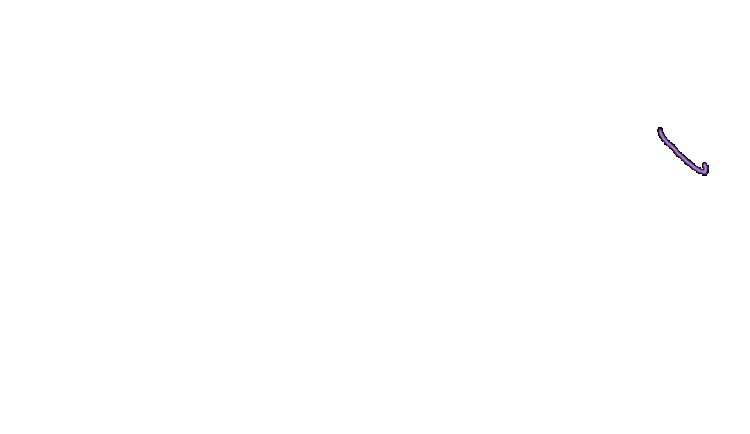
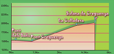
Location |
Plan de Bañs. Benasque. |
| Departure Point |
Plan de Bañs |
| Arrival Point |
Solana of Cregueña |
| Distance |
5Km. (Outward). |
| Approximate time |
2h (Outward) |
| Maximum height |
Solana of Cregueña - 2050 m. |
| Unevenness |
525m. |
Accumulated ascent |
550m. |
| Difficulty |
Medium - High |
| Suitable time |
Spring - Summmer |
| Notes of interest |
Route of medium - high difficulty because of the strong gradient throughout its length. Not require any special technique but at some stage have to make small grimpe without difficulty for traversing a stretch of rocks.
|
| GPS |
>>Download Track<<
|
|
|
|
| |
|
|
|
|
Location |
Plan de Bañs. Benasque. |
| Departure Point |
Plan de Bañs |
| Arrival Point |
Solana of Cregueña |
| Distance |
5Km. (Outward). |
| Approximate time |
2h (Outward) |
| Maximum height |
Solana of Cregueña - 2050 m. |
| Unevenness |
525m. |
Accumulated ascent |
550m. |
| Difficulty |
Medium - High |
| Suitable time |
Spring - Summmer |
| Notes of interest |
Route of medium - high difficulty because of the strong gradient throughout its length. Not require any special technique but at some stage have to make small grimpe without difficulty for traversing a stretch of rocks.
|
| GPS |
>>Download Track<<
|
|
|
|
|
|