| |
Home >
Garrotxa N.P.
|
|
�ndice de Rutas
|
|
| |
|
|
| |
|
| |
|

|
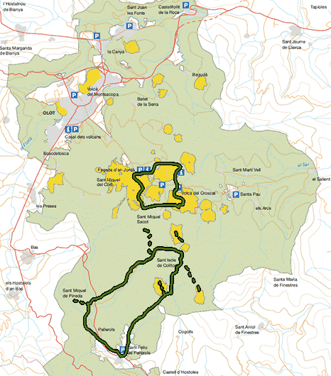
Natural park of half mountain located in the county of Gerona, to the northeast of Catalonia, concretely in the district of Garrotxa.
It has a surface of 13000Ha with 26 natural reserves (like the Fageda d'en Jord� and Croscat Volcano) that occupy a total of 980Ha.
Natural reserves are protected due to their botanical and geologic interest.
The Park contains the volcanic and rather conserved best landscape in the Iberian peninsula, with more than 40 inactive, but not extinguished volcanos and with more
than 20 mass of basaltic lava.The last eruptive episode took place about 11500 years ago and almost all the volcanos originated starting from an only eruption that
could have lasted from days until weeks. The explosive most habitual activity was the projection of volcanic bombs from materials accumulated around the chimney that
formed the volcanic cone. The pyroclastic and the lava flow that the volcanos emitted occupied the furrows of the rivers and they helped to make more fertile the plains
and the valleys were they crossed.
Most of the volcanos were created in two eruptive phases, the first caused by the materials that were deposited and the second due to the lava flow that deteriorate
the volcanic cones giving them horseshoe form in some cases.
The climate, the floor and the location provides a varied flora with more than 1000 varieties of plants with flower, forests of evergreen oaks, beech groves, oaks and
more than 250 species of animals.
You can travel the park making short walks of half hour until long trips of an entire day. The journeys are well signalled and there are points of information in
the most outstanding places in the park.
|
|
|
|
|
| |
| |
|
|
|
|
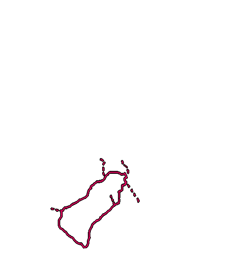
Location |
Garrotxa National Park |
| Departure Point |
Sant Feliu de Pallerols |
| Arrival Point |
Sant Feliu de Pallerols |
| Distance |
17Km (roundtrip) |
| Approximate time |
5h |
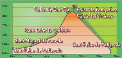
| Maximum height |
Fontpobra Volcano - 850m |
| Unevenness |
368m |
Cumulative Unevenness |
930m |
| Difficulty |
Middle |
| Suitable time |
All year |
| Notes of interest |
This route can be done on foot or in bicycle, there are some fountains on the road as well as mountain refuges where you can enjoy
the landscape.
This route can be done on foot or by bicycle, there are several fountains on the road and several castles (Castle Colltort, Castle Puig Alder ) and churches and some volcanoes like Can Tia, the Tuta, Fontpobra, Trait�.
|
| GPS |
>>Download Track<<
|
|
|
|
| |
|
|
|
|
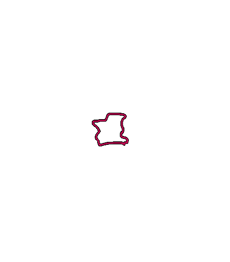
Location |
Garrotxa Natural Park |
| Departure Point |
Can Serra (Jorda's Beech) |
| Arrival Point |
Can Serra (Jorda's Beech) |
| Distance |
11Km (roundtrip) |
| Approximate time |
4h30m |
| Maximum height |
Volcano Santa Margarida - 700m |
Unevenness |
150m |
| Difficulty |
Low |
| Suitable time |
All year |
| Notes of interest |
Route to do with family to enjoy the famous volcanos of the Garrotxa Natural Park. There are alternative routes, all of them very well signalized.
|
| GPS |
No
|
|
|
|
|
|