| |
Home >
Aigüestortes N.P.
|
|
Índice de Rutas
|
|
| |
|
|
| |
|
| |
|

|
The park is located in the county of Lleida among the districts of Alta Ribagorça, Pallars Sobirà,
Pallars Jussà and Vall d'Aran. You can divide in two sectores: Aigüestortes and Sant Maurici.
The first sector is accessible from Alta Ribagorça through the valley of Boí and the second in Pallars
Sobirà if accessible from the valley of Espot.
It has a surface of 40.000 Hectares, although the park occupies some 14000, with abundant ponds and lakes (more than
200), creeks, torrents and cascades. Their origin is glacial, about 50.000 years ago the glaciers erode the landscape
until leaving it with the current aspect; the bends of the high mountain are in fact giving the name to the park.
In the routes that are described can be appreciate the wide variety of flora (forests of black pine, fir) and fauna
(ibex, golden eagles, salamanders...) that it will encourage you to visit him.
|
|
|
|
|
|
|
|
|
|
|
| |
| |
|
|
|
|
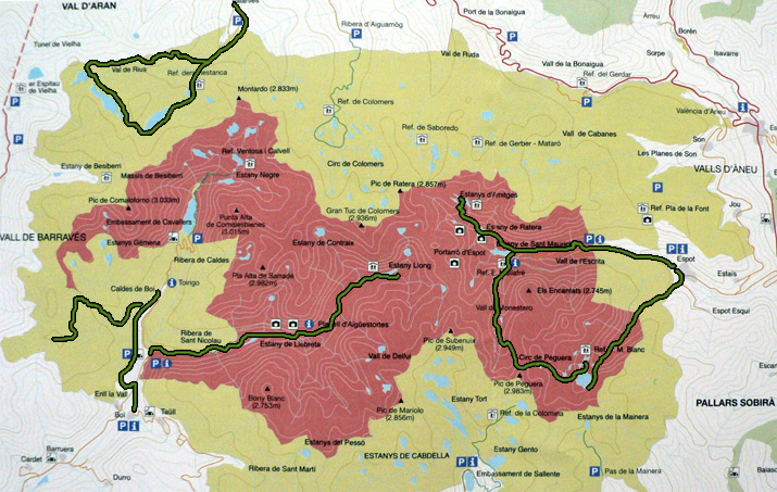
Location |
National Park in Pallars Sobirà |
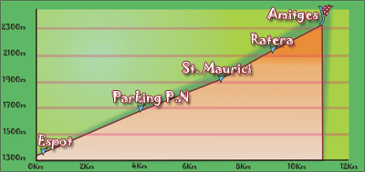
| Departure Point |
From Espot or from the parking at the entrance of the park (at 4km from Espot) |
| Arrival Point |
Refuge Amitges |
| Distance |
11Km (outward route) |
| Approximate time |
4h outward route- 2,5h inward route |
| Maximum height |
Refuge Amitges - 2380m |
Unevenness |
1063m |
| Difficulty |
Middle - Hight |
| Suitable time |
May - October |
| Notes of interest |
It is not allowed to go in car inside the park. It must be leave in established places. There is taxi-jeep service in the park |
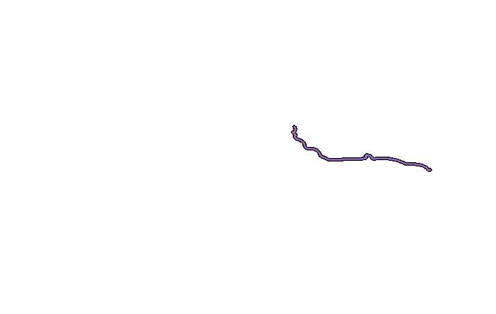
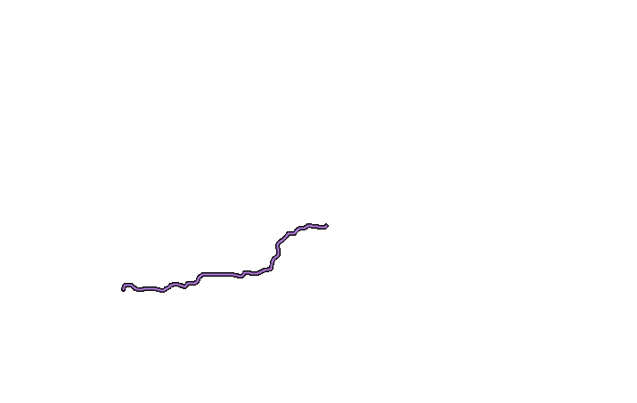
| GPS |
>>Download Track<<
(Only to St. Maurici)
|
|
|
|
| |
|
|
|
|
Location |
Nacional Park in Pallars Sobirà |
| Departure Point |
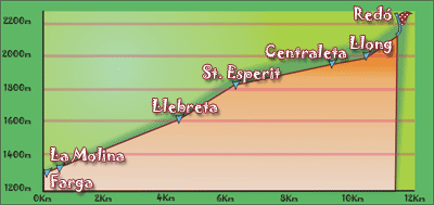
Parking of Farga |
| Arrival Point |
Pond of Llong |
| Distance |
10,5Km.(outward route) |
| Approximate time |
3,5h outward route - 2,5h inward route |
| Maximum height |
Pond of Redó - 2120m |
Unevenness |
820m |
| Difficulty |
Middle |
| Suitable time |
May - October |
| Notas de interes |
It is not allowed to go with car inside the park.
Part of the road is adapted to go with seat of wheels.
|
| GPS |
No
|
|
|
|
| |
|
|
|
|
Location |
Peguera Valley. Pallars Sobirà. |
| Departure Point |
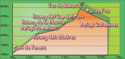
From Espot, deviation towards the station of local ski near the Bridge of Feners |
| Arrival Point |
Hill of Saburo |
| Distance |
9Km (outward route). |
| Approximate time |
5h outward route- 4h inward route |
| Maximum height |
Hill of Saburó - 2912m |
Unevenness |
1558 |
| Difficulty |
Middle-Hight |
| Suitable time |
June - October |
| Notes of interest |
Part of the route is not signalled and it is outside of paths. The route can be extended until arriving to the Refuge of Colomines
|
| GPS |

|
|
|
|
| |
|
|
|
|
Location |
Periphery of the natural Park in the Boí valley, Alta Ribagorça |
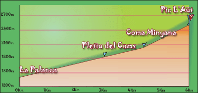
| Departure Point |
Palanca Parking |
| Arrival Point |
Peack Aüt |
| Distance |
5,8 Km.(outward route) |
| Approximate time |
4h outward route- 3,5h return route |
| Maximum height |
Peack Aüt - 2532m |
Unevenness |
1135m |
| Difficulty |
Middle |
| Suitable time |
June - October |
| Notes of interest |
-
|
| GPS |
No
|
|
|
|
| |
|
|
|
|
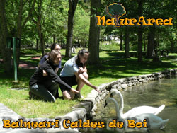
Location |
Valley of Boí. Alta Ribagorça. |
| Departure Point |
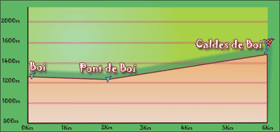
Place of Treio (Boí) |
| Arrival Point |
Caldes de Boí |
| Distance |
6Km (outward). |
| Approximate time |
2h |
| Maximum height |
Caldes de Boí - 1470m |
Unevenness |
200m |
| Difficulty |
Low |
| Suitable time |
All year |
| Notes of interest |
You can visit the spa of Caldes de Boí and enjoy the variety of the fountains and the different water types that flow out of them.
|
| GPS |
No
|
|
|
|
| |
|
|
|
|
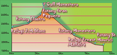
Location |
Refuge J.M. Blanc. Pallars Sobirà. |
| Departure Point |
Refuge J.M. Blanc |
| Arrival Point |
Lake of St. Mauricio |
| Distance |
11Km. (Outward route). |
| Approximate time |
7h (outward) |
| Maximum height |
Mountain pas of Monestero - 2724 m. |
| Unevenness |
823 m. |
Accumulated ascent |
740 m. |
| Difficulty |
High |
| Suitable time |
From spring to autumn, if we want to do it without snow, then in August. |
| Notes of interest |
In time of snow we must be equipped with crampons, and it could be that the milestones and signposts were hidden under the snow.
Route that goes through different lakes and where you can admire magnificents views from the Mountain pass of Monestero at National Park.
|
| GPS |
>>Download Track<<
|
|
|
|
|
|